

The project presented in this article is a piece of a broader design that involves the construction of a “green belt” interposed between the peripheral boundary of the building and the boundary of agricultural areas arranged along the last urbanized areas towards the east of the city.
The green belt thus conceived, is not configured simply as a park on a territorial scale, but is outlined as a “green device” capable of responding to the needs, in terms of regeneration, identity enhancement and environmental sustainability, of management of tangible and intangible heritage available to the Municipality as a public good.
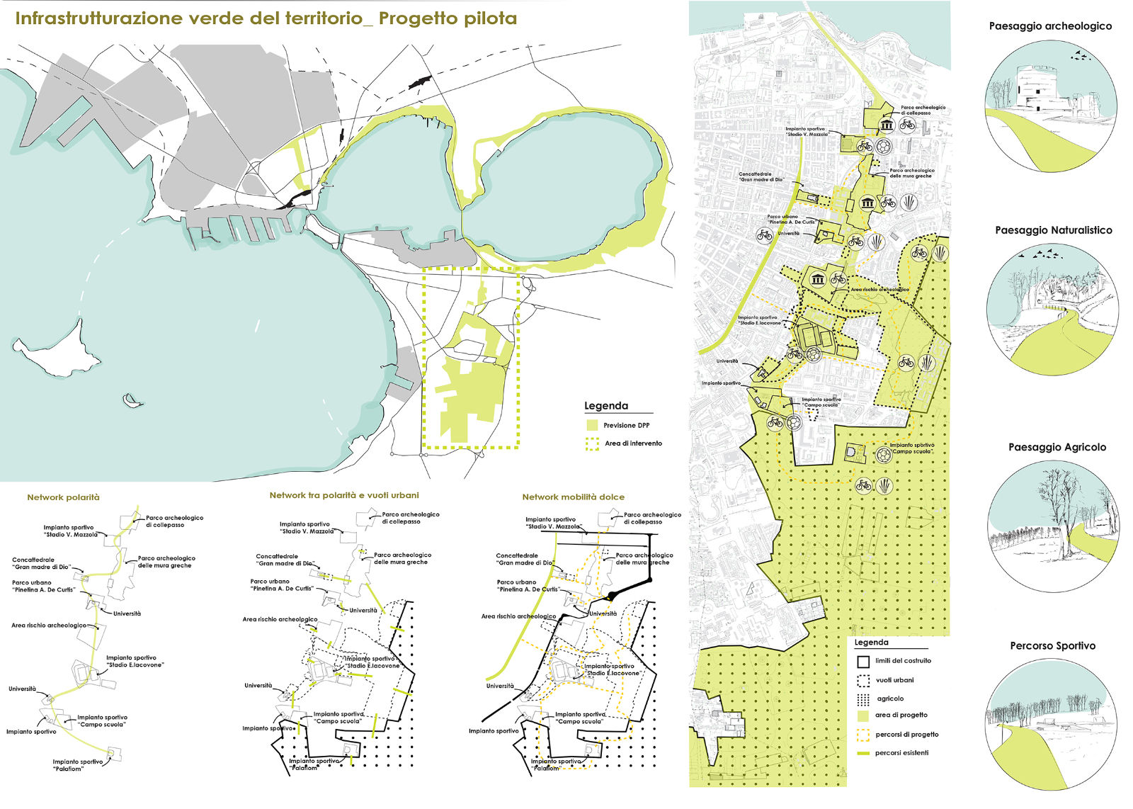
On a territorial scale, the green belt is configured as a green gateway to the city. The idea is to create a landmark in which the city recognizes itself and through which witness the green “turning point”. Taranto in recent years has become internationally famous for the environmental issue linked to the industrial sector of the former Ilva.
Although legitimate and incontrovertible, the environmental issue has contributed to the formation of a territorial image in which environmental, economic, historical, cultural and social resources are dramatically compromised and difficult to recover. Although still feeble and isolated, some initiatives have been put in place to reverse the course and project a new image of the city.
One of the most significant, is to be found in the one put in place by the municipal administration, for the drafting of the new PUG. This action, together with a decisive sharing of values and objectives with the stakeholders, must be the matrix in which to graft development policies and projects for the territory.
With this in mind, the project aims to be an experiment with which to test some principles of the D.P.P. of the new PUG, as well as of the PUMS and the Strategic Plan “Taranto Futuro prossimo” (“Taranto near future”) to promote soft mobility systems. Located on the eastern outskirts of the city, along the limit of the “built-up line”, the project acts as a “buffer” to protect urban sprawl, counteracting land consumption.
This buffer, made up of the peri-urban belt, is in direct contact, as well as with the urbanized part, also with the agricultural land, configuring itself as a buffer zone of the same, strengthening the city-countryside relationship, as indicated in the PPTR.
To realize the project in a tangible and “quick” action, it was necessary, after an analysis of the resources present in the intervention area, to map the attraction poles within the study area. As can be seen from the “Network polarity” scheme, the area is rich in attracting poles of various kinds, which in some cases are in a state of neglect and decay. Putting these places online would strengthen existing services and add new ones.
In order to put the mapped resources back into “circulation”, in the next step, the project searches for a connective tissue, capable of sharing the attracting poles with the entire territory in order to create an integrated system with the rest of the city.
The connective tissue has been identified in all those empty or disused areas that gravitate around or near the mapped poles. By acting on these areas, the effectiveness of the polarities can be “amplified”. For example, it was noted that in the vicinity of the E. Iacovone stadium in the area of the “Variant of the Contermini areas at CEP Salinella” and in the area affected by the “Taranto due” Executive Urban Plan there are numerous disused areas in which the installation of structures or sports facilities, including temporary ones, which, given the presence of other sports facilities in the vicinity, could amplify the sporting vocation of the area also for the purposes of the planned participation/organization of the Mediterranean Games in Taranto in 2026. The next phase provides for the infrastructure of the area.
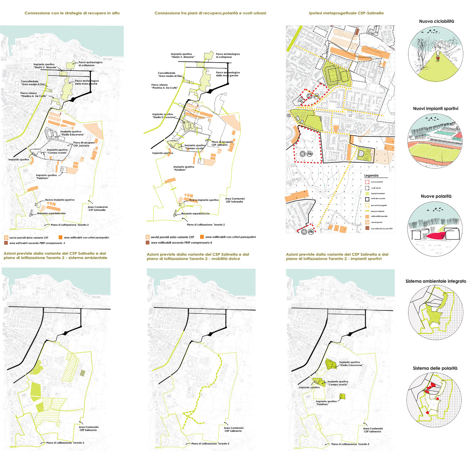
This is achieved by following the principles of environmental, social and economic sustainability, in the creation of a soft infrastructure capable of relating all the areas on which it will operate. In this way a network of paths is created, each with its own peculiarity.
You can easily switch from an agricultural landscape to an archaeological one (through the archaeological park of the Greek walls or the archaeological park of Collepasso) and still cross a naturalistic landscape by crossing the marshy area of the salt pans. All this within a unitary and integrated path.
The project thus created cannot simply be labeled as a park as it seeks to respond to the needs for the enhancement and recovery of disused properties, the increase and creation of new services and the urban regeneration of degraded areas.
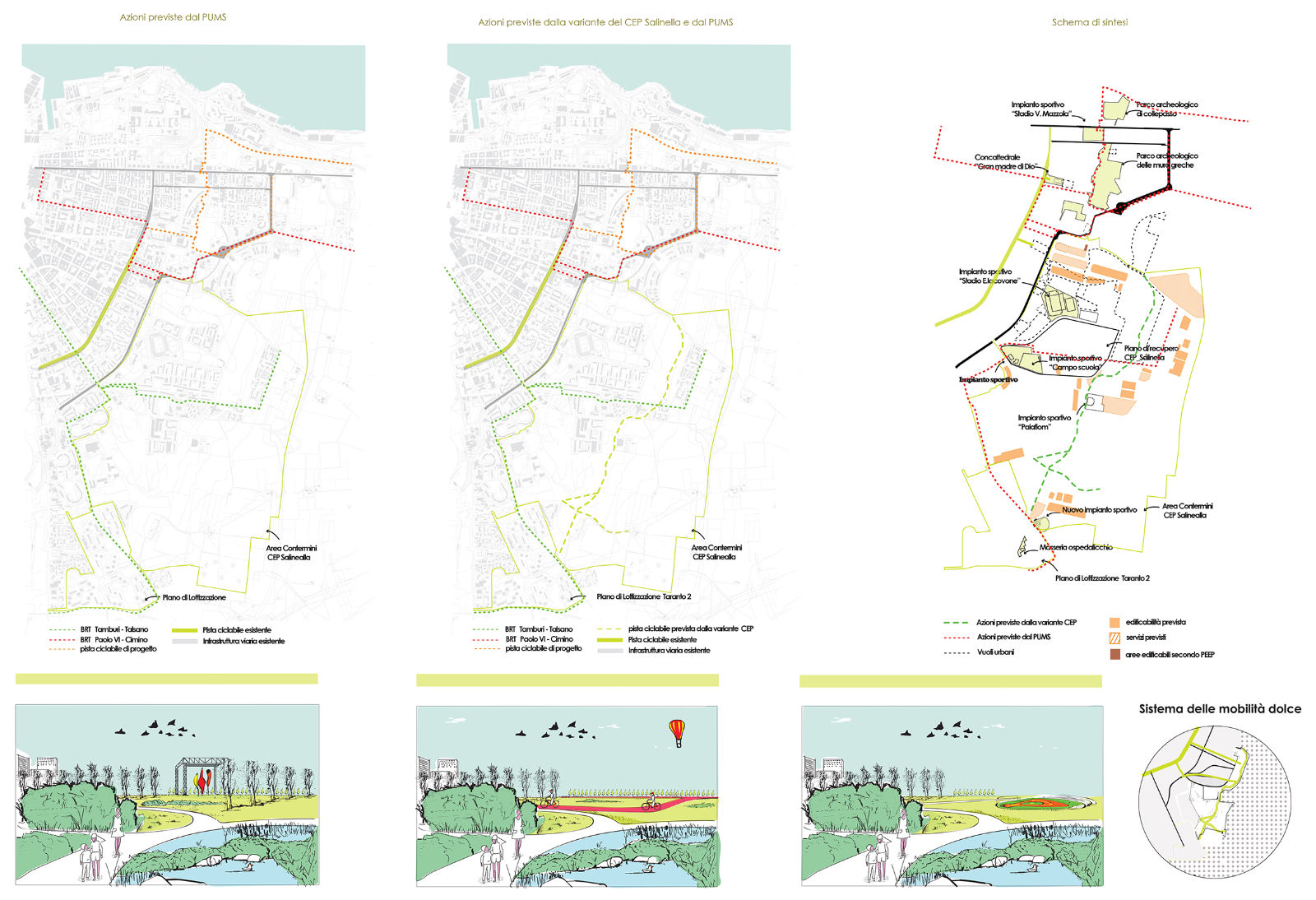
The pilot project thus becomes an excellent testbed for experimenting with new forms of urban management and planning to be replicated in other parts of the city. The proposed actions, to implement “the green infrastructure” through the pilot project that aims to: improve and/or integrate the sports facilities necessary to cope with the organization in Taranto of the planned Mediterranean Games (scheduled for 2026) and compete for the first road infrastructure for sustainable soft mobility according to the SUMP, find financial support in regional, national and EU programming also with the possibility of activating Public-Private Programs (P.P.P.) as provided, also in the final analysis, by DGC n.108 / 2020.
Roberto La Gioia – Mario Francesco Romandini